Jaranwala on the 1932 Survey of India Map
The villages around Jaranwala as the Survey of India printed them in 1932, from a survey made in 1910 and 1911. Search for a name your family remembers, zoom in, and see whether the same name is in the 2017 census.
- Surveyed
- 1910-11
- Printed
- 1932
- Scale
- 4 miles to the inch
- Names on this part
- 243
- Same name in the 2017 census
- 114
Survey of India sheet 44 E, "Lyallpur", third (revised) edition [1]. We read the names from the scan by eye; any reading we are not sure of is marked in the list.
Download the full sheet (JPEG, 1.9 MB) How to cite this page

Search the 1932 Map
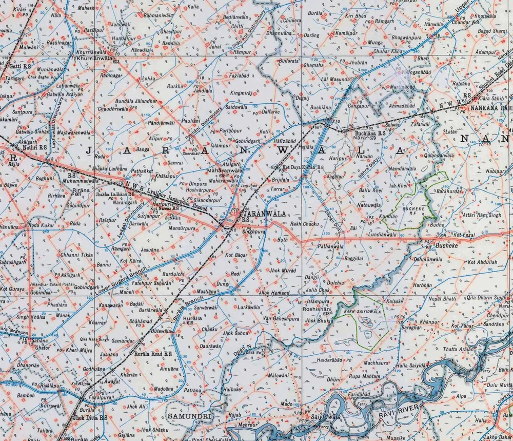
Drag to move the map and use the + and − buttons to zoom, or hold Ctrl and scroll. On a phone, tap the map to open it full screen. Map: Survey of India, 1932, public domain. Scan: Perry-Castañeda Library Map Collection, University of Texas at Austin [1].
All 243 Names on the 1932 Map
Every name printed on this part of the sheet, in alphabetical order. Choose a name and the map moves to it. 114 of them have a chak of the same name in the 2017 census, linked beside the name.
Names are spelled as the map prints them, marks over the vowels included. A name is only matched to a chak when the census places that chak in the same part of the tehsil. Even so, the same name is a lead, not proof that it is the same village, and where the census has more than one chak of a name, all of them are given.
No name matches. Try fewer letters: the map spells some names differently from today.
- Ādampur
- AhmadābādSame name in the 2017 census: Chak 559 GB
- AinuānaSame name in the 2017 census: Chak 273 GB
- Akālgarhnear Nethri
- Akālgarhnear Chhanni TikkaSame name in the 2017 census: Chak 117 GB, Akal Gar
- AlīpurSame name in the 2017 census: Chak 105 RB, Ali Pur
- Alpa
- AtalgarhSame name in the 2017 census: Chak 59 GB, Atal Garh
- Attāri Rām Singh
- ĀwāgatSame name in the 2017 census: Chak 276 GB, Awagut
- BadāliSame name in the 2017 census: Chak 26 GB, Budali
- BaggidalSame name in the 2017 census: Chak 629 GB, Bagidal
- Bagod Sharqi
- BāhmaniwālaSame name in the 2017 census: Chak 72 RB, Bahmani Wala
- Bājla
- Ballu Khel
- Bamboh
- Bandāla
- BangaSame name in the 2017 census: Chak 105 GB, Bonga (Banga)
- BannuSame name in the 2017 census: Chak 116 GB
- Baraghar
- BariārwālaSame name in the 2017 census: Chak 281 GB, Buriarwala
- Barkhurdār
- BediānwālaSame name in the 2017 census: Chak 61 RB
- Bhagwānpura
- Bhet
- Boghuni
- BrijdalaSame name in the 2017 census: Chak 237 GB, Burj Dula
- Bucheke
- Bucheke Reserved ForestForest
- Buchiāna
- Buchiāna RSRailway station
- Budhe
- Budorata
- Bundāla JālandharSame name in the 2017 census: Chak 103 RB, Bundala Jullundur
- Burālanorth of Jaranwala, near Shah Kot
- Burālasouth, near Jhok Ditta
- BurdulchiSame name in the 2017 census: Chak 23 GB, Borddlachi
- ButewālaSame name in the 2017 census: Chak 280 GB, Bootaywala
- Buth
- ButiwālaSame name in the 2017 census: Chak 123 GB, Boti Wala
- Chak Bagha
- Chak No. 73/19
- ChakkuSame name in the 2017 census: Chak 384 GB
- Chandar Kot
- ChaudhriwālaSame name in the 2017 census: Chak 106 RB, Chaudhry Wala
- Chendpur
- Chhanni TikkaSame name in the 2017 census: Chak 72 GB, Channi Tikka
- Chitti
- Chuhar Kāna
- Chukera
- DaffarkeSame name in the 2017 census: Chak 96 GB, Dufferke
- DāngliSame name in the 2017 census: Chak 631 GB, Dangali
- Darāng
- DariwālSame name in the 2017 census: Chak 67 GB, Dhari Wal
- DaurāwānSame name in the 2017 census: Chak 375 GB, Doranwan
- Dehmūnwāla
- DhannuānaSame name in the 2017 census: Chak 91 RB, Dhanoana
- DhanoriānSame name in the 2017 census: Chak 38 GB, Dhanurian
- Dhūni
- DīnpuraSame name in the 2017 census: Chak 62 GB, Din Pur
- Dogaij
- DulchiaSame name in the 2017 census: Chak 630 GB, Dolchia
- Dulu MultānReading uncertain: label cut by the crop edge
- DungiSame name in the 2017 census: Chak 355 GB
- Farīdābād
- Fatehpur SahorānSame name in the 2017 census: Chak 24 GB, Fateh Pur Sahuran
- Fazalpura
- FazlābādSame name in the 2017 census: Chak 96 RB, Fazal Abad
- GajiānaSame name in the 2017 census: Chak 436 GB, Gojiana
- GangapurSame name in the 2017 census: Chak 591 GB
- Gatti RSRailway station
- Gatwāla Arāiyān
- Gatwāla Sikhān
- GhasītpurSame name in the 2017 census: Chak 69 RB, Ghaseet Pura
- GhatorSame name in the 2017 census: Chak 39 GB
- Gobindgarhnorth of JaranwalaSame name in the 2017 census: Chak 60 GB, Gobind Garh
- Gobindgarhsouth-west of Jaranwala
- GobindpurMore than one chak has this name in the 2017 census: Chak 113 GB, Chak 115 GB, Chak 53 RB. The map alone does not say which.
- GobindsarSame name in the 2017 census: Chak 77 GB, Gobind Sar
- GodhuānaSame name in the 2017 census: Chak 278 GB
- HāfizābādSame name in the 2017 census: Chak 124 GB
- Haiboke
- Haidarābād
- Halla
- Halla Saiyidān
- Harbhān
- Haripurwest of JaranwalaSame name in the 2017 census: Chak 64 GB, Hari Pur
- Haripureast of JaranwalaSame name in the 2017 census: Chak 624 GB
- HoshiārpurSame name in the 2017 census: Chak 120 GB, Hoshiar Pur
- HundalpurSame name in the 2017 census: Chak 73 RB, Hundal Pur
- Isā KhelSame name in the 2017 census: Chak 567 GB, Issa Khel
- IslāmpurSame name in the 2017 census: Chak 102 GB, Islam Pura
- IslāmpuraSame name in the 2017 census: Chak 632 GB, Islam Pur
- Itānwāla
- JagātanSame name in the 2017 census: Chak 625 GB
- Jalandhar Safaid PoshānSame name in the 2017 census: Chak 118 GB, Jalundar Sufaid Poshan
- Jalib Chak
- Jandiāla
- Jandwāli
- JarānwālaTown
- Jasuānanorth of the Lower Gugera BranchSame name in the 2017 census: Chak 56 GB, Jasoana
- Jasuānasouth, near AwagatSame name in the 2017 census: Chak 279 GB, Jasso Anna
- Jhabrān
- Jhakka LadhānaSame name in the 2017 census: Chak 108 GB, Jakala Dhana
- Jhakka Ladhāna RSRailway station
- Jhok AliSame name in the 2017 census: Chak 362 GB
- Jhok Bhuki
- Jhok Ditta RSRailway stationSame name in the 2017 census: Chak 433 GB
- Jhok Hamand
- Jhok MurādSame name in the 2017 census: Chak 459 GB
- Jhok ShāshuSame name in the 2017 census: Chak 365 GB
- Jhok SohnaSame name in the 2017 census: Chak 580 GB
- JohalSame name in the 2017 census: Chak 97 RB
- KallaSame name in the 2017 census: Chak 68 RB, Kulla
- Kalsoke
- Kamālpur
- KanawarānSame name in the 2017 census: Chak 27 GB, Kanoran
- KartārpurReading uncertain: label cut by the crop edge
- KhālsāpurSame name in the 2017 census: Chak 106 GB, Khalsa Pur
- Khānpur
- KhāriānSame name in the 2017 census: Chak 277 GB
- KharrarSame name in the 2017 census: Chak 34 GB, Kharar
- Kheri MājraSame name in the 2017 census: Chak 36 GB
- Khotiwāla
- KhurriānwālaTown
- Kiāra Sāhib
- KingmirājSame name in the 2017 census: Chak 97 GB, King Miraj
- Kirāri
- Kiri Bhed
- Kot Abdullah
- Kot BāqarSame name in the 2017 census: Chak 353 GB
- Kot Daya Kishan RSRailway stationSame name in the 2017 census: Chak 236 GB, Kot Diya Kishan
- Kot Fazal
- Kot Guraya
- Kot KālraSame name in the 2017 census: Chak 57 GB
- Kot Nawāz RSRailway station
- Kot Rājput
- Kot Tāhar
- KotliSame name in the 2017 census: Chak 58 GB
- KundiānSame name in the 2017 census: Chak 570 GB
- Kutruwāl
- Lakho Dahar
- Lāl Masunda
- Latān
- LatiānwālaSame name in the 2017 census: Chak 200 RB, Lathianwala
- Lohka
- LundiānwālaSame name in the 2017 census: Lundianwala
- Lurkāwāla
- Machhaura
- Mado
- MadoānaSame name in the 2017 census: Chak 275 GB, Maduana
- Mahāranwālaupper of two places of this nameSame name in the 2017 census: Chak 61 GB, Muharan Wala
- Mahāranwālalower of two places of this nameSame name in the 2017 census: Chak 61 GB, Muharan Wala
- Mahesh
- MajāwaranwālaSame name in the 2017 census: Chak 211 RB, Mujawaran Wala
- Mālowāni
- MānakSame name in the 2017 census: Chak 31 GB
- ManeliSame name in the 2017 census: Chak 25 GB, Maneeli
- MansūrpuraSame name in the 2017 census: Chak 53 GB, Mansoor Pur
- Martinābād
- MastiānaSame name in the 2017 census: Chak 356 GB
- Mehrpur
- Muhammadwāla RSRailway stationSame name in the 2017 census: Chak 216 RB, Mohammad Wala
- Mulwāni
- Munga
- Muniānwāla
- Mupalke
- Nabipur
- Nāla
- NāmdārwālaSame name in the 2017 census: Chak 566 GB, Namdar Wala
- Nankāna SāhibTown
- Nāra
- NāraingarhSame name in the 2017 census: Chak 109 GB, Narain Garh
- NārwanSame name in the 2017 census: Chak 561 GB, Narwanwala
- Nathuwāla
- Nepāl Bhatti
- Nethri RSRailway station
- Pakkamāri
- PāndiānwāliSame name in the 2017 census: Chak 104 RB, Pahindian Wala
- PartābpurSame name in the 2017 census: Chak 100 GB, Partap Pur
- PathānkotSame name in the 2017 census: Chak 107 GB, Pathan Kot
- Pathānwāla
- PatiālaSame name in the 2017 census: Chak 234 GB
- PatrānaSame name in the 2017 census: Chak 377 GB, Patherana
- Pauliāni
- PhadiāraSame name in the 2017 census: Chak 32 GB, Phahara
- Pind JanjuhānSame name in the 2017 census: Chak 126 GB, Pind Janjua
- Pindi Cheri Kalān
- QalandarwālaSame name in the 2017 census: Chak 565 GB, Qalundar Wala
- Qila Dharm Singh
- Qila Hara SinghSame name in the 2017 census: Chak 29 GB, Qila Sardar Hara Singh
- RaīspurSame name in the 2017 census: Chak 111 GB, Rais Pura
- Rajab
- RājikiReading uncertain: label cut by the crop edge
- Rakh Chacku
- Rakh SaiyidwālaForest
- Rāmgarhnear Munga
- Rāmgarhsouth-west of JaranwalaSame name in the 2017 census: Chak 68 GB, Ram Garh
- RāmnagarSame name in the 2017 census: Chak 194 RB, Ram Nagar
- RāmpurSame name in the 2017 census: Chak 94 RB, Ram Pur
- Rānwāla
- Rasūlnagar
- RasūlpurSame name in the 2017 census: Chak 76 RB, Rasool Pur
- Ratoāna
- Rirāna
- Rirhāna
- Risālāpur
- Rodanorth of the railwaySame name in the 2017 census: Chak 109 RB
- Rodasouth, near Roda KukarSame name in the 2017 census: Chak 71 GB
- Roda Kukar
- RodiSame name in the 2017 census: Chak 354 GB
- Roshishāni
- Rupa Mahtam
- Rurāla Road RSRailway station
- Rurālla
- Rurkha
- Sāi
- SaidowālaSame name in the 2017 census: Chak 98 GB, Saidowal
- Saiyidwāla
- SamandarSame name in the 2017 census: Chak 283 GB, Samunder
- SamraiSame name in the 2017 census: Chak 104 GB, Sumra
- SamundriTown
- Sandrāna
- Santokhgarh
- Santpura
- SarwārwāliSame name in the 2017 census: Chak 382 GB
- Satiāna
- SelwānSame name in the 2017 census: Chak 586 GB
- ShāhāmadSame name in the 2017 census: Chak 282 GB, Chak Shahamad
- Shamsha
- SherābādSame name in the 2017 census: Chak 103 GB, Shehar Abad
- SikandarpurSame name in the 2017 census: Chak 122 GB, Sikander Pur
- Singh KhālsaSame name in the 2017 census: Chak 33 GB
- SinghpuraSame name in the 2017 census: Chak 240 GB, Singh Pura
- SurjanpurSame name in the 2017 census: Chak 66 GB, Sarjan Pur
- Taliāra
- Taragarh
- Tarrar
- Thatta Arāiān
- Vān GaneshpuraSame name in the 2017 census: Chak 583 GB, Wan Ganeshpura
- YounganābādReading uncertain: first letters faint
- ZafarwālSame name in the 2017 census: Chak 562 GB
What the Map Shows
A quarter-inch sheet: one inch on the paper is four miles on the ground. It covers a square degree of Punjab, from Lyallpur to Shekhupura, and the part shown here is Jaranwala tahsil and its edges. The tahsil's name runs across the middle in large spaced letters.
Villages and towns
Each village is a small red square with its name beside it. Jaranwala, Khurriānwāla, Nankāna Sāhib and Samundri are printed in larger letters.
Canals
Blue lines. The Lower Gugera Branch and the Burāla Branch cross the tahsil from north-east to south-west, and smaller distributaries such as Lakhuwāla, Pauliāni and Awāgat are named too. The Degh Nala and the Ravi are in the south.
Railways
Black and white lines, with stations marked RS. The Lyallpur-Jaranwala Branch of the North Western Railway comes in from the west through Nethri, Muhammadwāla, Jhakka Ladhāna and Kot Nawāz. Another line runs through Jaranwala from Buchiāna and Kot Daya Kishan to Rurāla Road and Jhok Ditta.
Letters beside a name
PO post office, TO telegraph office, PTO both, PS police station, RS railway station, IB inspection bungalow, RH rest house. A small triangle with a number is a survey point, with its height in feet above sea level: 623 at Khurriānwāla, 625 at Mahāranwāla.
Boundaries and forests
Grey dashed and dotted bands are district and tahsil boundaries. Green lines surround reserved forests, such as the Bucheke forest near Lundiānwāla.
Chak numbers
The map names villages, it almost never numbers them. On this part of the sheet only one chak number is printed, Chak No. 73/19, beside the Degh Nala. To go from a name to a chak number, use the census matches in the list above or Find Your Chak.
Jaranwala Before It Was a Town
The market town of Jaranwala was laid out in 1908, as the history page tells. The name is older than the town. The Gazetteer of the Chenab Colony, written in 1904, describes the Upera Kharrals, a grazing tribe of the Sandal Bar, the dry upland that the canal later watered:
“For these reasons the Upera Kharrals continued to reside personally in the Bár where in recent years they established a number of permanent settlements of considerable size, some of them right in the centre of the Bár, as at Páudiánwála and Ráo Khánuána, while [a name the print does not show clearly], Jaránwála, and Baryárwála were all well removed from the riverside. Consequently, when the irrigation of the Gugera Branch began they were all treated as nomad graziers, and received grants as such, their headmen becoming lambardárs and zaildárs in the tracts on the Burála Branch wholly occupied by themselves and their old dependents.”
So there was a Kharral settlement called Jaranwala in the Bar before canal water reached it, and the colony's new town carried a name that was already there. The same sentence names Baryárwála. The 1932 map shows a Bariārwāla near the Burāla Branch, south-west of Jaranwala, which is Chak 281 GB in the 2017 census. The gazetteer gives no location, so it may or may not be the same place.
“The largest branch of the canal, the Gugera, carrying about one-half the whole supply takes off at Sagar from the left bank of the main line at mile 28. It has a length of 55¼ miles and then bifurcates into two subsidiary branches, the Lower Gugera and Burála with lengths of 81 and 46 miles, respectively. The Burála Branch is of the two the nearer to the Rávi.”
That is the GB in a chak number: Gugera Branch. Both of its halves are on the 1932 map, the Lower Gugera Branch to the north-west of the Burāla Branch. How to read a chak number
Does Your Family's Village Appear on This Map?
If you find your family's village here, or know a name the map spells differently, tell us. With your permission, what families know goes on the chak pages for the next family searching.
Cite This Page
The map is in the public domain, and this page may be quoted with a link back. A suggested citation:
"Jaranwala on the 1932 Survey of India Map". jaranwala.com, checked 24 September 2026. https://jaranwala.com/1932-map/
Every name in the list has its own link, which opens the map on that village, for example https://jaranwala.com/1932-map/#v-banga. For the map itself, cite the Survey of India sheet [1].
Sources
- Survey of India, Punjab sheet No. 44 E, "Lyallpur", 1:253,440 (one inch to four miles). Surveyed 1910-11; first edition 1921, second 1928, third (revised) 1932. Scan by the Perry-Castañeda Library Map Collection, University of Texas at Austin (OCLC 181831961); archived copy. Public domain: a government map published in 1932, whose copyright term has ended.
- Gazetteer of the Chenab Colony, 1904, compiled and published under the authority of the Punjab Government. Lahore: Civil and Military Gazette Press, 1905. Pages 17 and 27, checked against the page images. Scan on the Internet Archive, from the Digital Library of India.
- Pakistan Bureau of Statistics, Population Census 2017, population by census block, Faisalabad district: the chak numbers and names used for the matches, as listed on Find Your Chak.
Checked 24 September 2026.